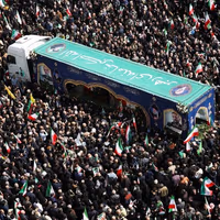
Light Magnitude Tremor Near Tehran A Warning For Future Quakes
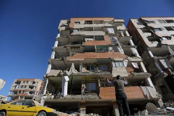
A magnitude 3.3 earthquake struck southeastern Tehran on Tuesday near Ghiamdasht county raising fears that the Iranian capital might be prone to stronger quakes.
A magnitude 3.3 earthquake struck southeastern Tehran on Tuesday near Ghiamdasht county raising fears that the Iranian capital might be prone to stronger quakes.
Mehdi Zare, a faculty member of the International Research Institute of Seismology and Earthquake Engineering, told Roydad 24 that Tuesday’s earthquake near Eyvanki fault indicates that it is still active, causing minor quakes.
“This fault zone, whose northwestern end reaches the 15th district of Tehran, has an earthquake-generating capacity of up to magnitude 7.5,” he warned. At least one and a half million people would die in case of an earthquake with a magnitude of 7 in Tehran, say experts.
The Tuesday morning quake was about 20 km southwest of Tehran and at a depth of 10 km (6.21 miles), the Volcano Discovery said.
Iran is crisscrossed by major geological fault lines and is one of the most earthquake-prone countries in the world because it is located where the Arabian, Indian, and Eurasian tectonic plates meet.
Iran has a history of massive earthquakes in recent decades, with some killing up to tens of thousands of people and causing billions of dollars in damages, such as the magnitude 6.6 quake in Kerman province in 2003 that killed 31,000 and flattened the ancient city of Bam.
Iranian officials have warned that there are 166,000 hectares of worn-out structures across the country which means a major earthquake like in Turkey and Syria could result in “hundreds of thousands of deaths.”


CBS News has also confirmed that the Federal Bureau of Investigation (FBI) is investigating Robert Malley, but the issue is not deemed a criminal matter.
However, a detailed report in Tehran Times about Malley's suspension and investigation has raised questions among former American officials and Iran watchers.
As presidential envoy for Iran, Malley was based at the State Department, his portfolio including both the attempts to resurrect a nuclear agreement with Iran (under the JCPOA), as well as negotiations over at least three American citizens who remain wrongfully detained by Tehran.
His suspension was first reported by Iran International June 29 and formally announced the following day by Matthew Miller, the spokesperson for the US State Department, calling it "a leave of absence”, adding that his duties would be temporarily assumed by his deputy, Abram Paley. However, it is believed he had been suspended as early as April.
According to the Tehran Times, a pro-regime publication, the exact date of Malley's suspension was April 21, when Malley was informed by the Diplomatic Security Department that due to his not having maintained classified documents, his security clearance was suspended.

The regime publication wrote: “His work-related accesses were cut off at this time. However, to prevent the matter from becoming public, some of his limited and non-critical accesses were maintained, such as his communication with the families of American prisoners in Iran.”
How a pro-regime outlet had such details, of which even Congress had not be informed, is raising serious questions. Frustrated by the lack of information sharing with the congressional committees overseeing the State Department, House Foreign Affairs Committee Chair Mike McCaul, Republican of Texas, sent a letter setting a July 11 deadline for the department to provide an update.
His letter claimed Congress had been misled about the reason for Malley's absence, which had been attributed to a family health matter. State Department spokesman Miller said in response: “We obviously got the letter from the Chairman; we've been reviewing it and we will be engaging with his office on the matter.”
The Tehran Times went into further detail, claiming that during the first few weeks of Malley’s unpaid leave, when Iran and the US held confidential negotiations in Oman, the US sent Brett McGurk, a member of the National Security Council who is close to Jake Sullivan. “The noteworthy point is that the Americans are trying to present the replacement of McGurk as a positive change and an effort to advance negotiations with Iran, hiding the Malley affair,” they wrote.
Ex-Iran envoy Gabriel Noronha pointed to the article as a worrying sign that sources in Tehran know more about the scandalous affair than Congress itself. Like many other Iran watchers, he highlights the closeness Malley has with key members of the regime. “His family's ties to notorious Iranian propagandists like Trita Parsi should be disqualifying in themselves,” he wrote.
Malley’s suspension has been of grave concern to the Biden administration, risking a controversy at a time which is critical to nuclear negotiations as Iran's uranium enrichment proceeds unhindered.
Alireza Nader from the National Union for Democracy in Iran said the matter risks becoming “a huge national scandal”, the Iran lobby possibly jeopardizing talks moving forward.
The Tehran Times article suggests the future of Malley’s career is bleak, revealing the depth of his connections to the regime: “Malley’s overly close proximity to his non-official Iranian assistants and advisers created the ground for the fall of this experienced diplomat.”